

| Chapter 1: | Geographical Advancements in the Mid-Tang |

|

|
Jia Dan was commissioned by Emperor Dezong’s court in 784 to draw an imperial map, after a rebellion that had threatened to bring down the empire.47 In his early career Jia had worked in the Foreign Affairs Department (honglu si 鴻臚寺) and used the opportunity to interview diplomats from neighboring countries and tributary states. He subsequently developed an extensive body of knowledge of foreign cultures and societies as well as geographic connections between the Tang Empire and foreign countries.48 As a result, he was said to be able to “distinguish, illustrate, and point out the origins and developments of all the plains and treacherous regions both within the country and without, and all the barbaric minorities’ aboriginal customs” (Jiuzhou zhi yixian, baiman zhi tusu, qufen zhihua, beijiu yuanliu 九州之夷險,百蠻之土俗,區分指畫,備究源流).49 Still, it took him more than a decade to actually draft the map and the accompanying encyclopedia-like map explanations. The map took its final form in 801, and Jia died four years later.
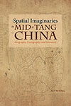
Although Jia’s map, like all other Tang maps, is no longer available today, a twelfth-century map carved on a stele, titled the “Map of Chinese and Foreign Lands” (“Huayi tu” 華夷圖), is considered by historians to be a later, simplified version of Jia’s map. The following is a transferred image of the stele: